Even the morning runs are uncomfortably warm and humid these days. Nephew Luke came by Tuesday morning and we ran 8.7 miles on the blacktopped Gateway Trail, from the parking area at Hwy 96 up to Pine Point Park and back. The girls ran the same route but turned around short of Pine Point. The temperature wasn't outlandish, going from 73 to 81, but the dew point in the 70's made it seem much worse.
I felt good at the start and we chugged right along at about a 9:00 pace on the way up to the park. But I fell apart on the way back, walked quite a bit, and the overall pace for the run was 9:56. I think I was dehydrated - next time I'll carry water when it's that uncomfortable. Luke seemed almost unfazed by the weather and, as always, had no trouble matching my pace.
He wore his Garmin again, and I learned something about the Gateway Trail. I had always assumed that Pine Point Park was the high point on this run, or maybe the little plateau at Co Rd 61 just a mile SW of the park. But it is actually just a half mile or so NE of the Hwy 96 parking area, the "Horse Bridge." The little chart shows a rather symmetrical elevation profile, as it should with an out-and-back run, with the small bump in the middle representing Pine Point Park. The highest point is near the start and finish. Not a big deal, of course, because the total excursion in elevation is only about 75 feet, but it's nice to know.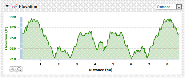
Luke's exact one-mile splits: 9:41, 8:47, 9:08, 8:55, 9:08, 9:46, 11:54, 12:04, 10:06, total 1:26:05 for 8.66 miles, pace 9:56.
Thursday, August 05, 2010
Hot Sticky Run
![]()
![]()
Subscribe to:
Post Comments (Atom)

2 comments:
For comparison, here's the graph with the "Elevation Correction" disabled. So I believe this graph shows the data captured directly by the watch while the other one must be based on GIS data.
Those are REALLY DIFFERENT. The corrected one is more symmetrical and certainly more credible.
Post a Comment